Hiking Trails in Europe is a part of a big series called “Best Hiking Trails in the World” suggested by Travel Bloggers around the world.
Read the best hiking trails from other continents below.
- Best Hiking Trails in Asia
- Best Hiking Trails in Africa
- Best Hiking Trails in Europe (You are Here)
- Best Hiking Trails in North America
- Best Hiking Trails in South America
- Best Hiking Trails in Oceania
Here is the list of Top hiking trails across Europe from top travel bloggers around the world.
List of Best Hiking Trails in Europe
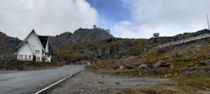
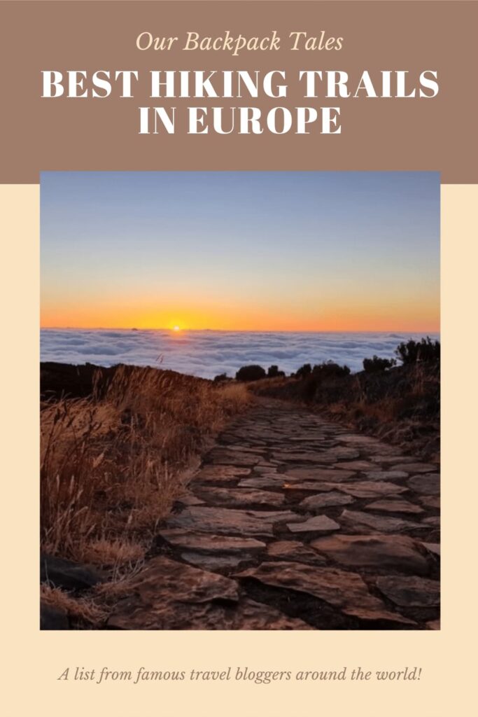
1. Rico Ruivo Sunrise Hike in Madeira

Written by Edyta from Say Yes To Madeira
Madeira is a beautiful Portuguese Island on the Atlantic, known to be real hikers’ paradise. It has an amazing network of mountain trails and levadas, which are small water channels used to transport water from the mountains. If you come here to hike, be prepared to be amazed.
You also have a chance to try some amazing sunrise hikes on Madeira. One of my favourite ones is the trail PR 1.2. to Rico Ruivo. Pico Ruivo (1,861 metres /6,106 ft) is the highest peak of Madeira and offers amazing panoramic coast-to-coast views. Seeing the golden sun rising above beautifully wrapped in clouds of mountains is a truly unforgettable experience. I recommend reaching Pico Ruivo just before dawn. If you are not properly equipped for a hike in the dark, do not worry – the sunrise will look beautiful from any point of the hike towards Rico Ruivo.
You can only reach the trail by car or with an organized tour. The closest parking is Achada do Teixeira, right next to where the hike begins. The distance is 2 x 2,8 Km and the hike should take you approx 1:30h in total. Madeira’s PR 1.2 hike is a well-marked out-and-back trail that connects with a couple of other interesting, more demanding trails. It mostly consists of a rock-paved path and its difficulty level is medium. You can download the hike’s map, together with maps of many other Madeira hikes on the official website or Visit Madeira.
2. Ben, Nevis, Scotland

Written by Rachel from Average Lives
Ben Nevis is in Fort William in the West of Scotland and is the tallest mountain in the UK. It is a 1345m ascent and 10.5miles round trip (17km). The trail can be difficult if you have not done the right training and usually takes around 7-9 hours to go up and down. Start the hike from the car park at the Visitor Centre at the bottom; here they have useful information and friendly staff to help plan your day.
There are several ways to reach the summit of Ben Nevis. However, if it is your first time climbing the mountain, you should take the Tourist Track, otherwise known as the Pony Track or Mountain Track. Over 125,000 people climb Ben Nevis every year, and you will feel a proud sense of achievement when you have completed it. The biggest tip to remember is to check the summit forecast before deciding when to climb the mountain.
The scenery is out-of-this-world, but Scottish weather is unpredictable so you need to plan for when or if it will be clear on the day you want to do this unforgettable hike. Wear appropriate footwear, take plenty of water and snacks and prepare for a challenging but rewarding day on one of the best hiking trails in the world.
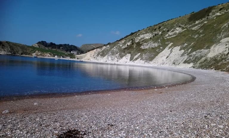
3. Lulworth Cove, Jurassic Coast in South West UK
Written by Angela from Exploring Dorset
Lulworth Cove on the Jurassic Coast in South West UK was formed around 10,000 years ago by the sea, now famous for its unique geology including Stair Hole and the Lulworth crumple.
There is ample parking near the cove (BH20 5RQ), with access to toilets and refreshments before starting out on the trails. The hills out of the cove reach elevations up to 168 metres at Bindon Hill, just out of Lulworth Cove.
One of the best hikes around Lulworth is towards Mupe Bay, a four mile circular walk with some tough inclines and descents. Don’t let the hills put you off as you will be rewarded with some fantastic views.
Starting from the carpark, walk around the large shingle cove and climb the wooden stairs at the far end. Your walk takes you through hedgerow towards the Lulworth lookout point at the top of the cove. This is a great place to stop for a picnic on a nice day.
The next part of the walk takes you across the army ranges in Dorset, with a good stretch of mainly flat walking before tackling the big hill out of Mupe Bay. This is the toughest part of the walk, however there are steps within the hill to assist you. Once you reach the top, the return journey follows the ridge along Bindon Hill and back down to Lulworth.
With plenty of options for a meal and a drink near the cove, why not enjoy a well earned rest.
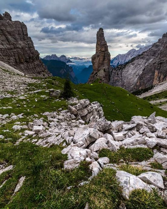
4. Campanile della Val Montanaia
Suggested by Miriam from Miry Giramondo
In 2009 the Friulian Dolomites were declared a UNESCO World Heritage Site. They extend between the provinces of Pordenone and Udine and are enclosed between the river Piave, the high course of the river Tagliamento, the Val Tramontina, and Val Cellina. Less known and frequented than the Venetian and South Tyrolean areas, the Friulian Dolomites offer breathtaking views and unexpected scenery.
They are an oasis for lovers of trekking, photography, wild watching, and climbing. The Friulian Dolomites Natural Park was created in 1996 within this beautiful natural setting: it covers an area of almost 37,000 hectares and is responsible for the protection and promotion of the territory. The symbol of these mountains is undoubtedly the Campanile della Val Montanaia, a daring rock tower unique in its kind, as isolated and far from the other mountain walls that surround it.
To reach it, the nearest airport is that of Venice then renting a car you get to the village of Cimolais and take the road of the Val Cimoliana up to the large parking of the refuge Pordenone from which starts the path Cai n. 353. In two and a half hours, with very steep stretches in the middle of screes and canals continuously modified by water erosion and with a difference in altitude of 800 meters you get to the bivouac Perugini from where you can enjoy a beautiful view over the valley. For the more experienced, there is also the possibility of climbing the famous bell tower on the top of which there is a bronze bell.
5. Vikos Gorge in North Greece

Suggested by Chrisoula from Greece Travel Ideas
Vikos Gorge lies in the Pindus Mountains, northern Greece, and is part of the Vikos–Aoös National Park, one of the most beautiful national parks in Greece Hiking the gorge is a real ‘must do’ as it is the world’s deepest gorge in proportion to its width. This remote mountainous region is known as ‘Zagori’ and has spectacular scenery, unique nature, architecture, and traditions. There are 46 villages- Zagochoria – where you will be warmly welcomed.
It is an amazing area to explore– especially in the springtime when it is warm and sunny and there are numerous wildflowers. The Vikos Gorge is spectacular and you can hike all day and see nobody!. Wear sturdy boots. Much of the hike is along a well-worn path, but there are places where scrambling is necessary. Take plenty of water as the only spring is at Klima.
The gorge stretches from the southern slopes of Mt Tymfi, 12 kilometers, and ranges in depth from 120-490 meters. In places, the gorge is 400 meters wide, and in others, just a couple of meters. The gorge was carved by the Voidomatis river which is seasonal – except in the lowest stretch near Vikos and is ideal for a swim!.
The gorge has some spectacular rock formations to see. As you walk towards Oxya, you will pass Petrodasos – the stone forest- rocky formations with defined horizontal layers of stone. One of the best vantage points is the monastery of Ayia Paraskevi, near the southern end of the gorge.
Vikos Gorge lies 30 km from Ioannina, capital of Epirus province. The best entrance into the gorge from Ioannina is 27 km north of the town, just outside the town of Karies or from Monodendri. There are routes of various lengths available to hikers or you can join an organized hike.
6. Cinque Terre in Italy

Suggested by Erki from Genem Travels
Cinque Terre hiking trails are located in the northwest of Italy. The whole area lies on a 20 km coastline with five picturesque villages, a National park, and of course several hiking trails. The closest city to the area is in north Genoa. It’s about 90 km away and easily reached either by car or train.
Cinque Terre has two main trails: Blue Path and High Path. The first trail is more popular, which connects all Cinque Terre villages. The 12 km trail winds along the Mediterranean Sea coastline with elevations starting from the sea level up to over 200 meters.
The other option is the High Path which winds along the edge of National Park with views over the Cinque Terre area and to the Mediterranean Sea. The 35 km trail starts from close-by village Portovenere passes all Cinque Terre villages and ends in Levanto. Elevations start again from sea level up to 800 meters.
There are some fees on the Blue Path trails. But with the Cinque Terre Card, these trails are included in the card fee. Also, it’s mandatory to wear proper shoes on hiking trails. Anything that covers toes and are well around your feet is good to go.
Hiking in Cinque Terre would be ideal to connect with your trip to famous Cinque Terre colorful villages. Hike trails offer magnificent coastal and landscape views all the way. In-between landmarks, smaller villages, and farms are also worth visiting.
7. Mestia to Ushguli Trail in Georgia

Suggested by Kristin from Adventures with Ensuite
The Mestia to Ushguli hike is located in the north western corner of Georgia on the border with Russia. 56km in total, the route takes you through ancient villages and picturesque valleys. It is normally completed over 4 days, although it can be completed in 3 days by taking a taxi part of the way.
Every day you experience a new valley and passes as high as 2,655m which brings with it some considerable climbing up and down but the impressive scenery changes make it worth the effort. Over the 4 days hikers pass glaciers and get great views of 5000 metre high mountains. Nights are spent in guesthouses in atmospheric villages which have changed little over the last few hundred years.
For directions it is recommended to download the maps.me app. The trail is fairly easy to follow but for some of the sections it is helpful to have the app to ensure you take the right path.
July to September is the best time for hiking in the region. The snow can sometimes linger until June but the main reason to avoid this month is that it can often be quite wet. It is recommended to book accommodation in advance since the most popular options will become booked up quickly, especially during school holidays.
Travelling to this World Heritage region takes time. Flights depart the capital Tbilisi a couple of times a week but they can only be booked from within Georgia and only operate when the weather is good. Therefore the best way to get to Mestia is by overnight train plus a 2-3-hour bus journey for the final stretch into the mountains. Buses are also available which take a minimum of 10 hours from Tbilisi. Whichever way you decide to travel to the region you will not be disappointed by the beauty of the Caucasus mountains.
8. Bohemian Switzerland in the Czech Republic

Suggested by Raluca from Travel With A Spin
Bohemian Switzerland National Park in the Czech Republic offers rock-climbing opportunities and hiking experiences for all levels. The most popular path is the one to the highest stone arch in Europe, Pravcicka Gate.
Hrensko, the village where the hiking path starts is less than two hours by car from Prague, making for an amazing day trip. The trail itself is about 3 km long and starts near Hotel Mezni Louka. It’s not too strenuous and most people can easily go through, but the last part is a bit steeper. On the way up, one will be enchanted by beautiful flowers, dense forests, sandstone formations and amazing viewpoints. The reward is pretty amazing, taking into consideration that the path itself is more on the relaxing side.
Pravčická brána, the target of the hiking trail, is the largest natural sandstone arch in Europe. Due to this record and its picturesque views, the 16 meters high arch became the symbol of Bohemian Switzerland. It was also used as filming location for the Chronicles of Narnia: The Lion, the Witch and the Wardrobe. Next to the gate stands Falcon’s Nest, a rustic chateau built in the 19th century. From beneath the arch, one can enjoy breathtaking views of the natural park. However, you should know that in order to get closer to the arch one has to pay a small fee. Make sure to have around 3€ on you.
Close by, in the same park, one can also go on the easy hike to the Gorges of Kamenice. This alternates walks and boat rides powered by smiling Czechs with long poles that push them along a narrow valley.
9. Pena Palace in Sintra, Lisbon

Suggested by Alice from Adventures of Alice
‘The hike up to Pena Palace was one that took me by surprise. I was staying in Lisbon at the time and when I decided to take a day trip to Sintra, I looked into all the possible routes up to the palace. There were two that came up most frequently, a tour bus or a tuk-tuk and I wasn’t keen on either. It took a while before I came across a third option – the hike – because a few people had discouraged the idea.
After taking the train from Lisbon station, I walked into the centre of Sintra itself. It was one of the most beautiful towns I’d visited in Europe and, after exploring for a bit, I went to find the tuk-tuks. I immediately realised that they were rather overpriced so, I decided to find the hiking route instead.
It wasn’t too hard to find, although Google Maps helped. There was a little path called the Villa Sassetti path off the main square, however, what I hadn’t realised at first, was that it was at the base of rather a steep hill.
Now, when I say steep, I mean virtually uphill all the way, although it was a varying degree of incline so it was easier in some parts than others. It took about an hour in total, including a few stops for photo opportunities. The walk was scattered with cute little sculptures and wooden chairs, birdbaths and even a flower arch. However, I suggest wearing shoes with good grip as the trail can be muddy in parts and slippery in others.
If you’re planning on doing this, be prepared to do a lot of walking in total. I think we walked 11 miles in total that day! But we did walk to and from the train station in Lisbon and to the other destinations in Sintra too. But, if you enjoy nature, gardens and beautiful walking trails, you won’t want to see Sintra in any other way.’

10. South West Coast Path in England

Suggested by Rich From RJonTour
The South West Coast Path is a long distance hiking trail that passes through some stunning parts of England. The entire route is over 600 miles, however most hikers choose a section at a time. This hiking route starts in Minehead in Somerset then asses through Devon, Cornwall then onto Poole Harbour at the finish point. Constant changes in terrain mean that over the entire route you have climbed the equivalent of climbing Mount Everest four times. If you wish to complete the whole of the South West Coast Path, they suggest allocating 52 days on average.
The South West Coast Path has many glorious sights on the route, however some are very significant. Clovelly in North Devon is absolutely stunning and a prefect English fishing village. Tintagel is famous for its links to the legend of King Arthur and Excalibur. Land’s End is the Most westerly point of England and Lizard Point lighthouse is the most southerly, both are rugged and attractive. Hikers then reach. Heading back into Devon, you pass through two cities, Plymouth and Exeter. The last leg takes you along the Jurassic Coast with sights such as Durdle Door to see.
Because most people do a section at a time, you can easily get to many start points by train or coach.
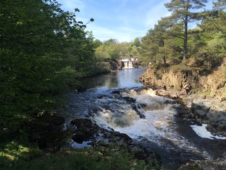
11. The Pennine Way in England
Suggested by Sarah from A Free Drink
The Pennine Way stretches for 268 miles through much of England’s high wild lands. It was England’s first National Trail and spans the Peak District to the Scottish Borders. It takes in the Yorkshire Dales, Hadrian’s Wall in Northumberland and the Cheviot Hills – all quite stunning, rugged and wild countryside. You’ll see some of the most glorious landscape, including waterfalls like England’s highest, High Force and the equally delightful Low Force.
The Pennine Way is the most challenging of England’s National Trails and has a combined ascent that is higher than Mount Everest! Its trails are often remote, and the route in its entirety is recommended only for experienced walkers – although many novices do walk it with a guide. The Pennine Way is best walked from the middle of May to September, but it can be walked year-round with the right gear.
The Pennine Way is arguably the most famous hike in England, perhaps the UK. It crosses stunning landscapes and you’ll meet the loveliest of people on this hike, but it is seriously recommended to build in breaks on the trip – you’ll pass through lovely towns and villages, so don’t just walk on through all of them!
The Pennine way is well signposted, but some of the terrain is remote. Walk safely, with the right equipment and clothes for the conditions and always advise someone as to where you are walking. Mountain Rescue Services in England are run by extremely well-trained volunteers and are superb, but don’t put yourself in the position where they have to be called out for you!
12. Gorropu Gorge Hike in Sardinia

Suggested by Claudia Tavani from Strictly Sardinia
There are many incredible hikes in Sardinia and the one to Gorropu Gorge is definitely one of the most popular ones. With its 500-meter-tall limestone walls, this canyon is one of the deepest and most impressive in Europe.
There are several trails that lead to the gorge. If you are looking for a trail that is suitable to the whole family, you should opt for Sa Barca Bridge trail, which starts at Rifugio Gorropu parking lot.
The trail is easy to follow and starts outside the mountain village of Dorgali and covers 14 km there and back on easy terrain and with very little ascent. The trail follows Rio Flumineddu, a nice river with several swimming holes where you can cool down in the spring months – unfortunately most of it dries out in the summer, when it’s too hot to hike anyways.
Factor in about 6 hours for the hike, to which you want to add some time in the actual Gorge. There is a €5 fee to access the gorge, which you pay at the entrance. You will need to bring food and water for the duration of the hike, and wear appropriate hiking gear.
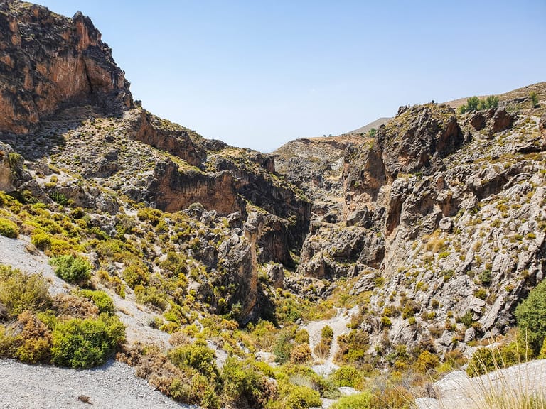
13. Ruta de Los Cahorros in Monachil, Spain
Suggested by Joanna from Andalucia in My Pocket
One of the most beautiful hiking trails in the South of Spain is Ruta de Los Cahorros in Monachil, in the Sierra Nevada National Park.
Monachil is a village located a few kilometres outside of Granada. To reach it you can either drive here, if you are exploring the South of Spain by car or go by public transport. There is a bus leaving the city centre of Granada regularly, reaching Monachil in 20 minutes. Make sure you check the schedule as during the weekend it doesn’t run very often.
Ruta de Los Cahorros is an adventure trail that has everything an adventure lover would like. The path starts with a gentle incline through the forest, following the Monachil river. Soon enough, you will have to cross the first hanging bridge. The longest hanging bridge of the trail is 55 meters long and goes over a beautiful waterfall into a narrow canyon. From here, the trail continues on the side of the vertical cliff wall on one side and the river on the other. From time to time, you will need to make use of the metal hangers in the cliffs in order to lean above the river and go around the rock formations. As the river is just half a meter below, it’s not dangerous, it would actually be quite hard to fall. It’s a fun trail popular with both adults and children. Many people choose to return back the same way, at the end of the canyon. For those who choose to continue, from here, the path climbs steeply up the mountain. This is where you will have plenty of chances to meet wildlife such as the Iberian ibex. Keep in mind though that this part of the trail is not shaded at all.
Ruta de los Cahorros is a circular hike, 7.2 kilometres long, classified as moderate. It is best attempted in autumn and spring, when the temperatures are still mild.
14. Black Peak in Bulgaria
Suggested by Eva Milano from Elevate Calm
Legend has it that a mother cursed her daughter for not wanting to marry any of her candidates. The young woman turned into black stone in the place we call today Black Peak. Standing at 2,290m, it is the highest point in the Vitosha mountain that borders the capital. Due to its proximity to the city, it is a popular hiking trail during all seasons. There are various starting points that lead up to the peak. The most preferred trail starts at the Moreni hotel as it is accessible for all levels of hikers. It is around 5km long and takes about 1:30h because it is not very steep.
You can also reach it by following the red markings from the Aleko hit. It takes as much time as the previous trail to walk the 3km route with a denivelation 482m.
I would highly recommend you to take the longer trail on the way up and the shorter one on your way down so you can experience them both. The best part about hiking the peak is sitting on the fields at the top and enjoying the view of nearby peaks and hills. On the weekends, you can also get hot tea, which is an excellent treat, especially in the winter.
15. Path of the Gods Trail in Italy

Suggested by Dymphe from Dym Abroad
One of the best hiking trails in the world is the Path of the Gods at the Amalfi Coast. This is a wonderful hiking trail that you will definitely remember! In the past, this hiking trail was used to get from the town of Bomera to the town of Nocelle. In fact, it was the only connection between the two towns. When you do this hike, be ready for amazing nature and incredible views of the Amalfi Coast!
To get to the hiking trail you need to take a bus from Amalfi to Bomerano. That’s where the hiking trail starts. There are white and red signs with 02 written on them that mark the hiking trail. When you follow these signs you eventually arrive at Nocelle. From that town, you can walk down several steps until you end up in the town of Positano.
This town is beautiful to see and there are amazing places for photography in Positano! The length of the hiking trail is about 4.8 miles or 7.8 kilometers. There aren’t many changes in elevation and the hike is relatively easy to do. If you want to make the most out of your hiking experience, I recommend staying for a night in Positano after the hike! The combination of nature, views, and beautiful towns is why I would recommend this hiking trail!
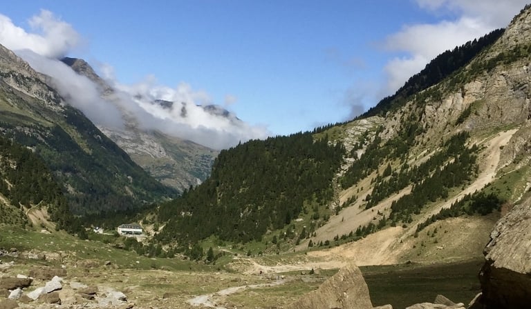
16. Cirque de Gavarnie in France
Suggested by Izzy from The Gap Decaders
High in the French Pyrenees is the Cirque de Gavarnie, a bowl carved out of the mountains by a glacier millions of years ago. The village of Gavarnie, in the Pyrenees National Park, is the starting point for the 8.5km hike, though beautiful countryside on well maintained paths.
The best part of the hike is within the le Cirque de Gavarnie itself, where you’ll find fields of wildflowers littered with sheep and goats and incredible waterfalls, including the Grande Cascade de Gavarnie, the highest in mainland France at 422m.
The start of the hike, which will take around 2-3 hours, is downhill from the main car park in Gavarnie, to the crossroads in the centre of the village. Follow the main street south and you’ll start to pick up markers and then the gravel track which takes you deeper into the mountains. The Cirque is visible from here, even from a distance you can see how it dominates the skyline and landscape.
There is a few hundred metres of steep track before you look up to see the Cirque and all its waterfalls right in front of you. You’re now at 1570m of elevation (having gained around 250m on the hike), with the highest walls of the Cirque topping 3,000m, and very possibly covered in snow.
The sparkling waterfall can be approached by continuing on the track, until you start to ascend the 150m of shale required to feel the drops on your face. This can be tricky as the shale is loose and steep. If you’re not sure-footed, poles will help here.
There are a couple of perfect spots for a packed lunch, by the small stream or in the valley flora, amongst the flora and fauna of this beautiful place.
17. E4 Trail in Crete Greece

Suggested by Antoine and Marielle of Offbeat Escapades
Situated in the Southern region of the Aegean Sea, Crete is the biggest of all the Greek islands, but also one of the more offbeat and adventurous places to visit. There are over 440 hiking trails on the island which promises hikers, at any level, a diversity of landscapes and backdrops.
The E4 trail from Sfakia to Agia Roumeli is one of the most beautiful hikes that Crete offers because it guarantees some jaw-dropping sceneries through the hike. You will be walking in the wild mountains, crossing the turquoise blue waters of the Libyan Sea, and even going through imposing gorges.
This trail is also the southernmost trail in the whole of Europe. The hike itself is for more experienced hikers (medium difficulty) as the trail can reach an elevation of up to 2,800 feet and takes about a total of 7 to 8 hours to complete. It’s also very rocky with temperatures getting very hot and the trail having minimal shade, so it’s essential to come prepared with lots of water and the appropriate hiking gear.
To get to the start of the hike, you need to reach the town of Chora Sfakion and walk to the jumpoff point on the highway following Ilingas Beach.
The hike itself passes through various beautiful destinations in the South Coast of Sfakia from Sweetwater Beach, Loutro Crete, Marmara Beach, and the Aradena Gorges, before finally arriving at Agios Pavlos, the gateway to the Agia Roumeli coast.
As a result, there are many opportunities to take a break in these stopovers by camping, swimming, or simply discovering the area.
18. Calanques of Marseille Cassis in France

Suggested by Elisa from France Bucket List
The hike through the Calanques of Marseille – Cassis is one of the most beautiful trails in France. It is inside the Calanques National Park in the region of Provence, Southern France. This French national park is the only one in Europe, which is at the same time terrestrial, marine, and periurban, with many hiking options. Here, you can walk, dive, swim, and rock climbing, that’s why we like it so much.
The hike through the Calanques of Marseille – Cassis follows the coast and connects all the calanques between the communes of Marseille and Cassis. A calanque is the name given to the secluded beaches in this part of Southern France, and any of these calanques are the perfect for a break, picnic under the sun, or a refreshing bath.
There are many points of access to this hike, so it can be as long as you want. It is not an easy hike – it follows the coast, but it goes up and down – and it is especially tough during the summer or when the mistral wind blows. Therefore, the best time to walk this hike is in early spring, when it is warm but not too hot.
The best way to reach the hiking trails is by car, but there’s also a local bus leaving Marseille to one of the access points. Also, you can take the train to Cassis and start walking from the town and then back.
19. Tre Cime di Lavaredo, Dolomites in Italy

Suggested by Krisztina from She Wanders Abroad
If you’re looking for the best hiking trails in the world, especially in Europe, look no further than the Italian Dolomites! Covering more than 140,000 hectares, there are no shortage of amazing hiking trails in the Dolomites, ranging from easy treks to challenging multi-day hikes. One of the most popular trails in the Dolomites is the Tre Cime di Lavaredo hike, and it’s easy to see why!
The entire loop is a bit over 10kms with 430m elevation gain, which means it’s accessible to almost everyone, even for elderly people or families with little children. The hike can easily be completed in 3-4 hours but since the scenery is breathtaking, you might want to calculate with some extra time for sightseeing.
The starting point of the hike is Rifugio Auronzo, which is easily accessible via public bus or car. It’s important to know that driving up is only possible if you pay the extra 30 EUR for using the private road leading up to Rifugio Auronzo.
Once you’ve made it there, you can decide to do the Tre Cime di Lavaredo hike clockwise or counter clockwise. Since this is a loop hike it doesn’t really matter, although it’s better to do it counter clockwise as this way you’ll be facing the tree majestic peaks of Tre Cime di Lavaredo the entire time.
The trail is quite straightforward and easy to follow. There are three other rifugios along the way that can serve as checkpoints during your hike, and you can also stop for a refreshing drink or a hearty meal at any of them.
20. Trolltunga in Norway

Suggested by Jiayi from The Diary of a Nomad
Trolltunga, a stunning rock formation in Norway, offers one of the most breathtaking hiking trails in the world. This rock actually has the shape of a tongue; in fact, it sticks out horizontally out of a cliff, which is partly what makes it so unique.
Trolltunga has a distance of 28 km and the entire hike will take around 10 to 12 hours roundtrip, depending on your personal pace. This hike isn’t easy — you’ll be climbing up almost 800 meters and will likely feel exhausted unless you’re used to hiking such distances. However, as a famous hiking quote says, “everything worthwhile is uphill.” And worthwhile it so is, because Trolltunga offers some of the most breathtaking landscapes in the whole of Norway.
Throughout the hike, you’ll be mesmerized by the gorgeous views of the fjords, mountains, and streams surrounding you. It’ll feel like stepping into a whole other world, because everything looks stunningly surreal. Definitely take your time appreciating the impressive panorama throughout this hike; it’s one of the main reasons it’s so famous.
Once you reach the rock formation at the end of the trail, you can step out onto the rock to enjoy an absolutely incredible view of the fjords below you. This is also a very popular photo spot, so be prepared to wait in line for it. In fact, during the peak season of summer, you could very well be waiting in line for 3 hours, so I highly recommend you to start the hike early in the morning so that you can reach the destination before most of the other visitors do!
The easiest way to get to the Trolltunga hiking trail is to base yourself in Odda, a tiny town closeby. You can drive to Odda from large cities like Bergen or Stavanger in 3 to 3.5 hours.
21. Arthur’s Seat in Edinburgh

Suggested by Anuradha from Country Hopping Couple
Arthur’s Seat is one of the iconic and proud symbol of Edinburgh. The 350 million years old extinct volcano is the highest point in Edinburgh that offers sweeping views of the city. It is a popular hiking/walking route not just for locals, but tourists as well. Needless to say, a visit to Edinburgh is incomplete without climbing up Arthur’s Seat.
Located as part of Holyrood Park, Arthur’s Seat is approximately 1 mile away from Edinburgh Castle. Parking spaces are available in Queens Drive, behind Holyrood Palace (paid parking), and near St.Margaret Loch (free parking). During the summer months, it is extremely difficult to get parking spaces. If you are relying on public transport, bus #35 and #6 takes you to Holyrood Palace/Scottish Parliament, which is close to where the hiking trail begins.
There are different routes to climb to the summit of Arthur’s Seat with varying difficulty levels. And you can choose to do a linear trail or a circular loop, depending on the time you have. The summit is 251 metres high, and a circular trail distance to summit is approximately 2.3 miles. On an average it takes 2 to 2.5 hours to finish the loop.
Our personal favourite is to take the route through the ruins of St.Antony’s Chapel and follow the path to the summit. Walks include grassy and rocky climbs that could be steep in parts. From the summit take the grasslands to Salisbury Crags and back to the car park. Do bear in mind, there is an alternate route that are really steep patches in parts of this route. Avoid this route if you are faint hearted! That said, climbing Arthur’s Seat is family friendly (kids love hiking this too! ) and requires less to moderate fitness levels.
22. Camino de Santiago in Spain
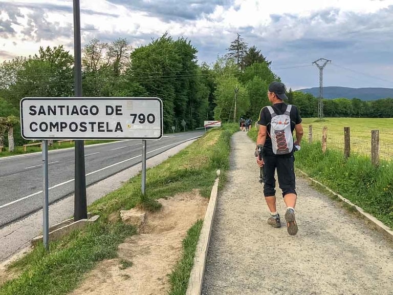
Suggested by Carol Guttery from California Crossings
The Camino de Santiago (or The Camino) is a 1,000 year old network of pilgrimage routes which all end in Santiago Spain. The cathedral in Santiago houses the remains of Saint James, and it’s long been a place for the faithful to find spiritual guidance and forgiveness. The modern day Camino has also attracted many non-Catholic pilgrims who are seeking self-discovery and a good long walk.
The most popular Camino trail is the Frances. It starts in St Jean Pied de Port France, goes over the Pyrenees and ends up in Santiago 780 kilometers (500 miles) later. The terrain goes over a few mountain ranges with up to 1,000 meters of elevation, but most of the trail is rolling hills and countryside.
Walking the Camino is a very personal thing and you can do as much or as little of the trail as you wish. Most people take 30-45 days to complete it, sometimes over multiple years.
This is what I did. My first Camino was intended as a re-boot after deciding to make a major life change. The second, because the Camino got into my blood and I wanted to explore more of the trail.
If you want to do the Camino, consider the late spring or early fall as the weather is very nice and you’ll avoid crows on this very popular trail. Bring a 35 litre pack, three days of clothes, an open mind and the will to keep walking. As they say on the trail…Buen Camino!
Save this post in Pinterest
Latest Posts
- York England Itinerary from London Guide 2024

- Must visit hotels that are castles in UK

- Top places to visit in Wayanad in 2024

- Skandagiri Hills Night Trek 2024- A Complete Guide
- Munnar Travel Guide for 2024

- A Sikkim Travel Guide 2024: 7 Days in Sikkim