Hiking Trails in South America is a part of a big series called “Best Hiking Trails in the World” suggested by Travel Bloggers around the world.
Read the best hiking trails from other continents below.
- Best Hiking Trails in Asia
- Best Hiking Trails in Africa
- Best Hiking Trails in Europe
- Best Hiking Trails in North America
- Best Hiking Trails in South America (You are Here)
- Best Hiking Trails in Oceania
Here is the list of Top hiking trails across South America from top travel bloggers around the world.
List of Hiking Trails in South America
1. Sierra Nevada Trail, Chile

Suggested by Stéphanie from Bey Of Travel
Conguillio National Park is without a doubt one of the most beautiful national parks in Chile.
Located within the Biosphere Reserve Las Araucarias, and extending over 60,000 hectares (150,000acres). There are Five volcanoes in Conguillío park including Volcano Llaima, one of the most active volcanoes in Chile. It also includes the volcano Sierra Nevada and the expansive Lake Conguillío. The park is known for its beautiful lagoons and araucarias – these trees are national monuments and are world-famous.
You can enter the park through both the north and the south. The beautiful entrance road will astonish you instantly; the volcanic scenery is reminiscent of the landscape where dinosaurs used to live.
The most popular hike in the park is the Sierra Nevada Trail. Make sure you plan the time of your visit wisely. If you want to go hiking October/November and March/April/May are the ideal months. This 10 km tour was declared by the Lonely Planet as one of the most beautiful short hikes in Chile. The trail is fairly steep, but the trees create much-needed shade from the blazing sun. After 45 minutes you will reach the first viewpoint with a magnificent view over Lake Conguillio and the Sierra Nevada volcano.
The trip is suitable for anyone, children and the elderly. We even spotted a couple of condors during the hike! After the hike, you can stay in Melipeuco for a lovely homestay with an excellent breakfast. For more info or bookings, click here.
2. Senda Costera in Tierra del Fuego National Park, Argentina

Suggested by Audrey from That Backpacker
If you’re looking for an unforgettable hike at the very end of the world, you cannot miss Tierra del Fuego National Park in Argentina!
The hikes in the park vary in length and level of difficulty, however, one of my favourites is Senda Costera which follows the coastline. This means you are treated to a mix of the subantarctic forest as well as beautiful coves and secret beaches. There are lots of nice spots to stop and rest along this trail, so it’s a nice idea to pack a picnic and enjoy a leisurely hike.
The Senda Costera trail starts in Zaratiegui Bay, where you can visit the End of the World Post Office (and mail a postcard while you’re at it!) and it finishes at Alakush Visitors Centre. The shuttle to the park stops at both locations, so you can do the hike in either direction, but I’d recommend doing it from Zaratiegui Bay to Alakush since there’s a cafe at the end and that seems like a nice reward.
This particular hike is 8 kilometres in length, medium difficulty, and takes between 3-4 hours to complete. It’s a fairly flat trail, but you do encounter some steeper sections the closer you get to Alakush.
It’s also important to note that the best time for hiking in Tierra del Fuego National Park is between November and March since certain trails within the park do close once it begins to snow.

3. Pedra da Gávea in Rio de Janeiro, Brazil

Suggested by Bruna from I Heart Brazil
One of the best hikes I did was the famous trail to Pedra da Gávea in Rio de Janeiro. Not necessarily because of the trail itself, but because of the summit’s view.
For starters, Pedra da Gávea is a massive monolithic mountain (about 2,769 feet high) next to the Atlantic Ocean. Once at the summit, you can see everything. No, seriously. You literally see the whole Rio de Janeiro City sprawling from the greenish Tijuca National Park to the Brazilian coast’s blueish sea. It’s the pure definition of mind-blowing, and adventure lovers can’t possibly visit the city without hiking this challenging trail–it’s a must!
But no pain, no gain.
It’s an out-and-back trail that takes about 3 hours to complete, but if you’re traveling during the Brazilian summer (Dec-Feb), you will want to start your hike in the morning as the summer days can be unbearable around lunchtime.
Last, because the terrain is uneven and steep, find yourself a local guide who can show you exactly the path to the summit and back.
Oh, and some other handy tips for this trail are:
- Pack repellent
- Use sunscreen and wear a hat
- Bring water, snacks, and a trash bag
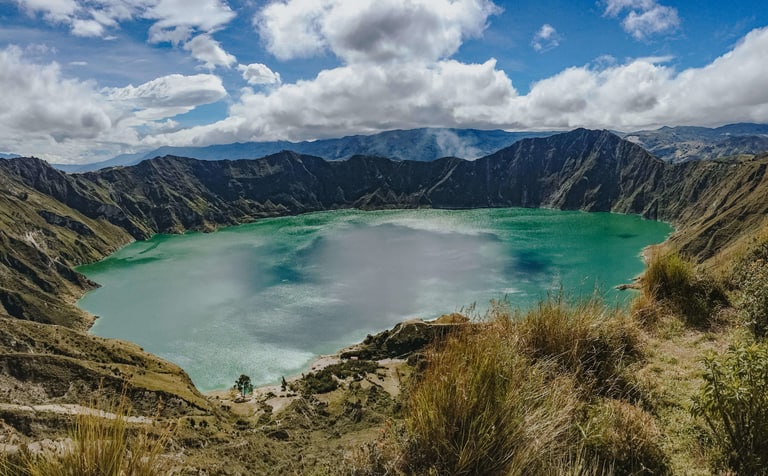
4. Quilotoa Loop in Ecuador
Suggested Carley from Home to Havana
Known as being one of the best treks in South America, the three-day Quilotoa Loop taking hikers through some of the most stunning scenery in the Andes mountains of Ecuador. Taking hikers through small, indigenous villages and to high mountain lookouts, this trail is one to be remembered.
The trek starts or finishes at the Quilotoa Crater Lake, a stunningly bright blue lake inside the crater of an extinct volcano. The crater lake is one of the most famous landmarks in South America, and a truly jaw-dropping sight – it will take your breath away if the altitude in this area of the Andes hasn’t already. Hikers generally take a bus from the nearby city of Latacunga to the start of the trek in Sigchos, then continue through Isinliví, Chugchilán, and finally endings at the crater lake in Quilotoa. While starting in Quilotoa and ending in Sigchos means you’ll have already seen the most beautiful sight – the crater lake! – on the first day of the hike rather than finishing with it, this route tends to be easier, with less ascent.
For those looking to experience the beauty of Quilotoa without a few days to commit to hiking the entire Quilotoa Loop, day trips or overnight stays in the small town of Quilotoa, overlooking the crater lake, are easily arranged from Quito or nearby Latacunga. The hike around the crater rim is also a stunning one, of moderate difficultly and lasting about four or five hours.
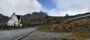
5. Mirador las Torres in Patagonia

Suggested by Cecilie from Worldwide Walkers
One of the most popular hiking trails in South America is the Mirador las Torres base hike in Patagonia. It’s an incredibly beautiful trail that leads to the iconic viewpoint of the three granite towers, which are standing tall above a clear blue glacial lake.
It’s an 18-kilometer hike that takes between 8-10 hours depending on how many breaks you take, the amount of people on the track, and your level of fitness. The elevation gain is about 900 meters/3000 feet until you reach the viewpoint and then return down the same track.
The hiking trail is located in Torres del Paine National Park in the Southernmost region of Chile, also known as Patagonia. You can either book a hiking tour or you can do the hike by yourself. If you go by yourself, you have to stay in Puerto Natales from where you can catch the bus to the National Park.
Mirador las Torres is a very popular trek, and it can sadly get overly crowded. So, the best thing you can do to avoid the crowds is to leave with the earliest bus in the morning or avoid visiting in the peak season that goes from December to February.
Walking the Mirador las Torres base track is without a doubt one of the best and most beautiful trails in the world! So, make sure to stop by this hike if you ever find yourself in the South of Chile.
6. Fitzroy Trek in Argentina

Suggested by Claudia Tavani from My Adventures Across The World
There is little doubt that the hike to Laguna De Los Tres is among the best in the world. The trail goes to a lagoon that is the best view place to get views of Mount Fitz Roy, a mountain in Argentine Patagonia.
The best access point for the hike is El Chalten, a tiny village in the heart of the Patagonia region, about 3 hours drive from El Calafate. From El Chalten, you have the option of walking to the beginning of the trail – in which case your hike will be a there and back; or get a ride to Hosteria El Pilar, 12 km north, from where you can walk to the lagoon and then continue all the way to El Chalten.
The second option will give you a bit more variation in terms of views. Either way, you will be walking for 24 km, on good terrain. For the most part the hike is moderate. Once you get to Campamento Poincenot, however, it becomes difficult: you will be scrambling uphill on a 40% incline over large boulders, which are also difficult to tackle on your way back downhill.
That 1 km will take you about 1 hour. Once you are finally up, you will have the best views of Mount Fitzroy. On the way back to town you can make a quick detour to visit the Chorrillo del Salto, a scenic waterfall perfect for a break. There is no actual trail to get there, but the roar of the waterfall will guide you.
The trail is very well marked, free to access and easy to do without a guide. You will have to carry whatever you will need for the day – food, water, sunblock. Factor in between 6 and 8 hours for the hike, depending on how long you stop at the lagoon. Try to visit on a clear day for full views of the mountains.
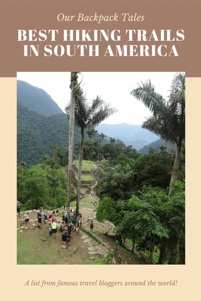
7. Lost City Hiking Trail in Colombia

Suggested by Becky from Becksplore
Ciudad Perdida (engl. Lost City) is an archaeological site located in the Sierra Nevada de Santa Marta mountains. Visiting the Lost City is an incredible experience, so if you have the time, a hike to to the Lost City should be included in any Colombia itinerary.
The ancient city can only be reached by foot as part of a multi-day hike through the Colombian jungle. Therefore, the hike itself can only be done as part of a tour and is usually completed within 4 days. The tour will cost you around 1.150000 COP (around $350 USD) and will include transportation to the starting point of the trail, food and accommodation in one of the camps along the hiking trail, entry to the Lost City and a tour guide and translator.
The total distance of the hike is 44 km (28miles) and the highest point is Ciudad Perdida itself, which lies at 1200 metres above sea level.
The closest bigger cities near the starting point of the track are Santa Marta and Palomino. Due to the hike being four days long and the humidity, make sure you have a good level of fitness, as the track can be quite challenging. You will also have to cross a few small rivers towards the end of the trip. Make sure to bring sunscreen, bug repellent, maybe a portable charger, comfortable clothes and a bathing suit.
Finally reaching the Lost City has been one of the most rewarding experiences and I can highly recommend this trek to everyone. Along the way you will also meet some of the local tribes who live in the Sierra Nevada de Santa Marta mountains and learn about their life and culture which is super interesting.
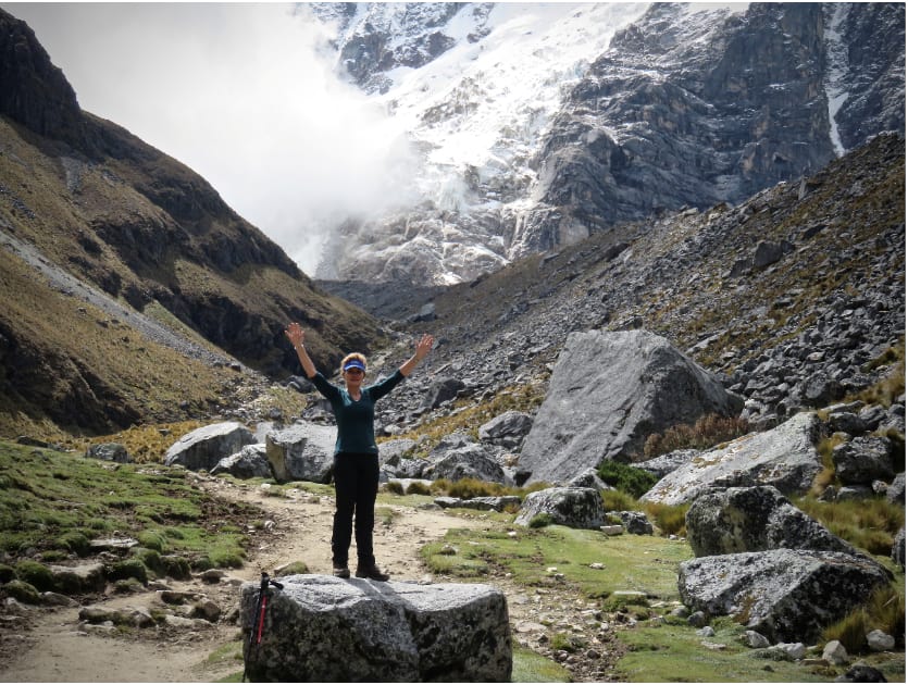
8. The Salkantay trek to Machu Picchu in Peru
Mimmie from Adventure Travel Coach
Visiting Peru is every adventure traveller’s dream destination. And not only is The Salkantay Trek in Peru one of the best ways to explore the magical land of the Incas, but it will also lead you to Machu Picchu, one of the 7th wonders of the ancient world. The 4–5-day amazing Salkantay Trek to Machu Picchu is a hike over 74km. It is filled with picturesque valleys, imposing mountains with various flowers, orchards, birdlife, small rodents, and other animals.
Highlights of the hike
- Visit the most beautiful and famous Humantay Lake on your very first day.
- Hike up the Salkantay Pass while admiring glaciers reaching a altitude of 4 630 meters where the magnificent turquoise Salkantay lake awaits.
- We were passing through villages, coffee plantations and meeting locals, experience Andean culture.
- At night camp under the stars while enjoying the fresh mountain air.
- Finish the trek in the small town of Aguas Calientes, the gateway to Machu Picchu. Relax your tired body at the Hot Springs of Aguas Calientes.
- Explore the legendary Machu Picchu.
At its highest point, it is 4,635 meters or 15,200 feet. Those who are planning to do this trek will want to plan to spend at least two days in Cusco
How to get there?
The most popular way to travel from Cusco to Mollepata would be by Minibus. should you book a guided tour, they will pick you up at your hotel at about 4.
Quick information and Tips
- Make sure to acclimatize for at least two days before the start of the hike.
- The use of a Tracking pole will take some pressure off your knees,
- Pack only the necessary items in your backpack or daypack.
- Dress in layers, and remember to take a waterproof jacket as the weather can be unpredictable in the mountains.
- The sun is harsh in the mountains; therefore, apply sunscreen.
- Wear comfortable trail shoes.
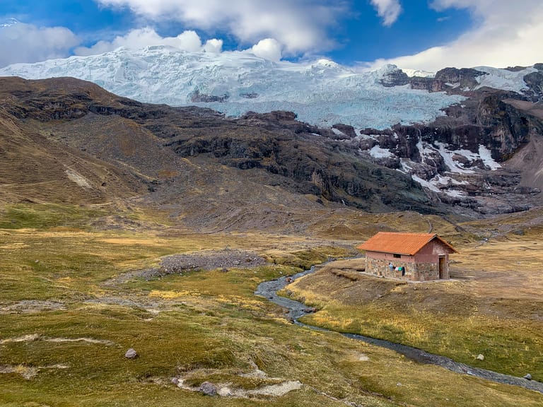
9. Ausangate Trek with Rainbow Mountain in Peru
Suggested by Megs from Packing up the Pieces
The Ausangate trek in Peru continues to top the world’s best hikes list. Located three hours to the south of the Imperial City of Cusco, this high altitude multi-day trek never dips below 14,000 ft. and circles around the towering Ausangate Mountain (20,945 ft).
The trail is tough, but the rewards are so worth it. Experience some of Peru’s most gorgeous scenery like turquoise and red alpine lakes, glacial covered mountains, and unique landscapes, all without the crowds. This intrepid 6 day trek includes a stop at the popular Rainbow Mountain, so you can savor in those incredible views without the crowds. There are three major mountain passes, the highest over 17,000 feet! Share the trail with thousands of alpacas, and maybe spot some wild vicuña, or the fluffy, yet cute rodents of vizcachas.
From Cusco, it’s possible to reach the village of Tinki via public transportation. Upon arrival, take a taxi to the official trailhead in Upis, but you may wish to soak in the small hot springs with Ausangate towering in the backdrop. Over the next few days, be prepared to not see many people, maybe a few women shepherds, so proper gear is essential. Bring a reliable tent, a sleeping bag that can withstand freezing temperatures at night, proper cooking gear, a water filter, a few battery packs, and enough food for at least 5 days. There won’t be any shops or tiendas along the way.
At these heights, acclimation is crucial, so purchase coca leaves at the local market to help alleviate any altitude sickness (and leave behind as gifts for safe passage to the mountains). On the final day, walk into the tiny hamlet of Pacchanta, where you can reap the final reward of yet another hot spring. From here, catch a taxi to Tinki, where frequent buses depart for Cusco.
Pin this post
- York England Itinerary from London Guide 2024

- Must visit hotels that are castles in UK

- Top places to visit in Wayanad in 2024

- Skandagiri Hills Night Trek 2024- A Complete Guide
- Munnar Travel Guide for 2024

- A Sikkim Travel Guide 2024: 7 Days in Sikkim